Joshua Tree National Park
| Joshua Tree National Park |
|
|
|
|
| Location |
Riverside County and San Bernardino County, California, United States |
| Nearest city |
Twentynine Palms, San BernardinoNearest city: Twentynine Palms, San Bernardino |
| Area |
789,745 acres (319,598 ha) |
| Established |
October 31, 1994 (1994-10-31) Established: October 31, 1994 (1994-10-31) |
| Visitors |
1,256,421 (in 2006) |
| Governing body |
National Park Service |
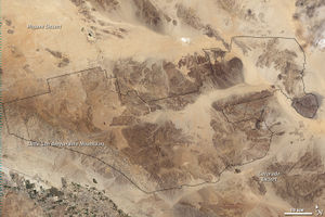
Joshua Tree National Park on a 2003 Landsat image
Joshua Tree National Park is located in southeastern California. Declared a U.S. National Park in 1994 when the U.S. Congress passed the California Desert Protection Act (Public Law 103-433), it had previously been a U.S. National Monument since 1936. It is named for the Joshua tree (Yucca brevifolia) forests native to the park. It covers a land area of 789,745 acres (319,598 ha). A large part of the park is designated to wilderness area—some 429,690 acres (173,890 ha). Straddling the San Bernardino County/Riverside County border, the park includes parts of two deserts, each an ecosystem whose characteristics are determined primarily by elevation: the higher Mojave Desert and lower Colorado Desert. The Little San Bernardino Mountains run through the southwest edge of the park.[1]
Geography and botany
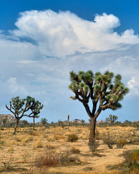
The park is named after the Joshua tree.
Mojave Desert
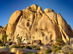
The higher, drier, and slightly cooler Mojave Desert is the special habitat of Yucca brevifolia, the Joshua tree for which the park is named. It occurs in patterns from dense forests to distantly spaced specimens. In addition to Joshua tree forests, the western part of the park includes some of the most interesting geologic displays found in California's deserts. The dominant geologic features of this landscape are hills of bare rock, usually broken up into loose boulders. These hills are popular amongst rock climbing and scrambling enthusiasts. The flatland between these hills is sparsely forested with Joshua trees. Together with the boulder piles and Skull Rock, the trees make the landscape otherworldly.
Joshua trees dominate the open spaces of the park, but in among the rock outcroppings are piñon pine, California juniper (Juniperus californica) and scrub oak.[2] These communities are under some stress, however. The climate was wetter until the 1930s. The same hot and dry conditions that provoked the Dust Bowl affected the local climate. These cycles were nothing new, but the original vegetation did not prosper when wetter cycles returned, however. The difference may have been human development. Cattle grazing took out some of the natural cover and made it less resistant to the changes. But the bigger problem seems to be invasive species, such as cheatgrass. These things deliver a double punch. During wetter periods, they fill in below and among the pines and oak. In drier times, they die back, but do not quickly decompose. This makes wildfires hotter and more destructive, which kills some of the trees that would have otherwise survived. When the area regenerates, these non-native grasses form a thick layer of turf that makes it harder for the pine and oak seedlings to get a roothold. This is not a very generous environment and there are not that many second chances.
Colorado Desert
Below 3,000 feet (910 m), the Colorado Desert encompasses the eastern part of the park and features habitats of Creosote bush scrub; Ocotillo, desert Saltbush and mixed scrub including Yucca and Cholla cactus (Cylindropuntia bigelovii). There are areas of such cactus density they appear as natural gardens. The lower Coachella Valley is on the southeastern side of the Park with sandy soil grasslands and desert dunes.
The only palm native to California, the California Fan Palm (Washingtonia filifera), occurs naturally in five oases in the park, rare areas where water occurs naturally year round and all forms of wildlife abound.[1]
Geology
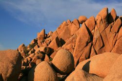
Giant Marbles
Climbing the Old Woman Rock
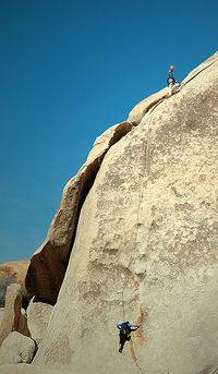
Climbers in Hidden Valley Campground in March 2008
The rock formations of Joshua Tree National Park were formed 100 million years ago from the cooling of magma beneath the surface. Groundwater is responsible for the erosion that created the spheres from rectangular blocks.[3]
Recreation
Camping
Nine established campgrounds exist in the park, only two of which (Black Rock Canyon and Cottonwood) provide water and flush toilets. A fee is charged per night for each camping spot.[4] Backcountry camping, for those who wish to backpack, is permitted with a few regulations.[5]
Hiking
There are several hiking trails within the park, many of which can be accessed from a campground. Shorter trails, such as the one mile hike through Hidden Valley, offer a chance to view the beauty of the park without straying too far into the desert. A section of the California Riding and Hiking Trail meanders for 35 miles through the western side of the park.[6] The lookout point at Keys View, towards the south of the park, offers views of the Coachella Valley and Salton Sea.
Nature walks inside the park include:
- Hidden Valley
- Indian Cove
- Cholla Cactus Garden
Longer trails include:
- Lost Horse Mine
- Lost Palms Oasis
- Fortynine Palms Oasis
Climbing
The park is extremely popular with rock climbers (who often refer to it as "JTree" if they are locals). It was originally a winter practice area while Yosemite Valley and other parts of the Sierra Nevada were snowbound, but later became an area of interest in its own right. There are thousands of named climbing routes, at all levels of difficulty. The routes are typically short, the rocks being rarely more than 230 ft (70 m) in height, but access is usually a short, easy walk through the desert, and it is possible to do a number of interesting climbs in a single day. The rocks are all composed of quartz monzonite, a very rough type of granite made even more so as there is no snow or ice to polish it as in places like Yosemite.
Driving
The Geology Motor Tour is located in the south of the park and provides a self-guided tour for those visitors with a four-wheel drive vehicle. There are sixteen stops on the tour showcasing the region's geology.[7]
Birding
There are over 250 species of bird in the park including resident desert birds such as the Greater Roadrunner and Cactus Wren as well as Mockingbirds, Le Conte's Thrasher, Verdin and Gambel's Quail. There are also many transient species that may spend only one or two seasons in the park. Noted birding spots in the park include: fan palm oases, Barker Dam and Smith Water Canyon. Queen Valley and Lost Horse Valley also provide good birding but with a different range of species because of the lack of water. These are often good places to see Ladder-backed Woodpecker and Oak Titmouse. A USGS Bird Checklist of "what, when, and status" has 239 species listed for the park.[8]
Wildlife
A good place to view wildlife is at Barker Dam, a short hike from a parking area near Hidden Valley. Desert Bighorn Sheep and Mule Deer sometimes stop by the dam for a drink. Tours of the Barker Dam area are available. Mountain Lions and Coyotes prowl the desert hillsides in search of the weak and injured.
Wilderness
Of the park's total land area of 789,745 acres (319,598 ha), 429,690 acres (173,890 ha) are designated wilderness and managed by the National Park Service (NPS) in accordance with the Wilderness Act. The NPS requires registration for overnight camping at specific locations called registration boards. Other requirements include the use of a camp stove as open campfires are prohibited and employing Leave No Trace camping techniques (also known as "pack it in, pack it out").[9] Although bicycles are not allowed in wilderness areas, horses are, but a permit must be obtained in advance for travel in the backcountry.
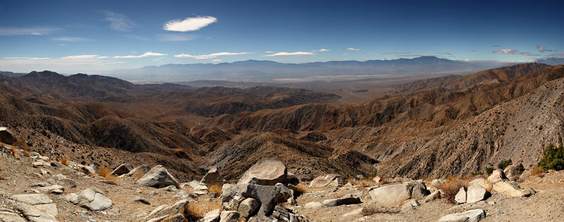
Panoramic 360° view of Joshua Tree Park
Panorama of the view south from the popular Keys View in the Little San Bernardino Mountains, Joshua Tree National Park, California. Visible landmarks are the
Salton Sea (230 ft/70 m below sea level) at rear left, along towards the center the Santa Rosa Mountains behind Indio and the San Jacinto Mountains behind
Palm Springs. In the valley floor, the
San Andreas Fault is clearly visible. At the rear right is the 11,500 ft (3,500 m) San Gorgonio Mountain.
Notes
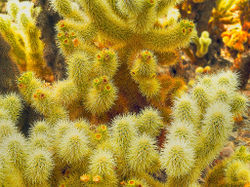
Teddy-bear cholla (Cylindropuntia bigelovii) at the Cholla Cactus Garden, Joshua Tree National Park
See also
- Cahuilla
- Mojave and Colorado Deserts Biosphere Reserve
References
- Birds, Joshua Tree National Park Association
- California Desert Protection Act-1994, PDF document
External links
|
World Deserts |
|
| Desert · List of deserts · List of deserts by area |
|
| Africa |
Algerian · Bayuda · Chalbi · Danakil · Djurab · Eastern · Ferio · Farafra · Kalahari · Libyan · Namib · Nubian · Nyiri · Richtersveld · Sahara · Ténéré
|
|
| Asia |
Ad-Dahna · Arabian · Aral Karakum · Aralkum · Badain Jaran · Betpak-Dala · Cholistan · Dasht-e Kavir · Dasht-e Lut · Dasht-e Margoh · Dasht-e Naomid · Gurbantünggüt · Gobi · Hami · Indus Valley · Judean · Karakum · Kharan · Kumtag · Kyzyl Kum · Lop · Nefud · Negev · Ordos · Qaidam · Rub' al Khali · Russian Arctic · Registan · Saryesik-Atyrau · Syrian · Taklamakan · Tengger · Thal · Thar · Tihamah · Ustyurt Plateau · Wahiba Sands · Liwa
|
|
| Europe |
Accona · Bardenas Reales · Błędów · Cabo de Gata · Deliblatska Peščara · Hálendi · Oltenian Sahara · Ryn · Tabernas
|
|
| North America |
Alvord · Amargosa · Baja California · Black Rock · Carcross · Channeled scablands · Chihuahuan · Escalante · Forty Mile · Gran Desierto de Altar · Great Basin · Great Salt Lake · Great Sandy · Jornada del Muerto · Kaʻū · Lechuguilla · Mojave · Okanagan · North American Arctic · Owyhee · Painted Desert · Red Desert · Sevier · Smoke Creek · Sonoran · Tule (Arizona) · Tule (Nevada) · Yp · Yuha · Yuma
|
|
| Australia |
|
|
| South America |
Atacama · La Guajira · Los Médanos de Coro · Monte · Patagonian · Sechura · Tatacoa
|
|
| Polar regions |
|
|
| project · category · commons |
|
|
Protected Areas of California |
|
|
National Park System |
|
|
| National Parks |
|
|
| National Preserves |
Mojave
|
|
| National Monuments |
Cabrillo · Devils Postpile · Lava Beds · Muir Woods · Pinnacles · World War II Valor in the Pacific National Monument
|
|
| National Seashores |
Point Reyes
|
|
| National Historical Parks |
Rosie the Riveter/World War II Home Front · San Francisco Maritime
|
|
| National Historic Sites |
Eugene O'Neill · Fort Point · John Muir · Manzanar |
|
| National Memorials |
Port Chicago Naval Magazine
|
|
| National Recreation Areas |
Golden Gate · Santa Monica Mountains · Whiskeytown
|
|
|
|
|
State Parks |
|
|
| State Parks |
Ahjumawi Lava Springs · Andrew Molera · Angel Island · Annadel · Año Nuevo · Anza-Borrego Desert · Arthur B. Ripley Desert Woodland · Bidwell-Sacramento River · Big Basin Redwoods · Big River · Border Field · Bothe-Napa Valley · Burton Creek · Butano · Calaveras Big Trees · Castle Crags · Castle Rock · Caswell Memorial · China Camp · Chino Hills · Clear Lake · Crystal Cove · Cuyamaca Rancho · D. L. Bliss · Del Norte Coast Redwoods · Donner Memorial · Eastshore · El Escorpion · Emerald Bay · Fort Ord Dunes · Fremont Peak · Garrapata · Gaviota · Great Valley Grasslands · Grizzly Creek Redwoods · Grover Hot Springs · Hendy Woods · Henry Cowell Redwoods · Henry W. Coe · Humboldt Lagoons · Humboldt Redwoods · Jedediah Smith Redwoods · Julia Pfeiffer Burns · Leo Carrillo · Limekiln · MacKerricher · Malibu Creek · Manchester · McArthur-Burney Falls Memorial · Mendocino Headlands · Mendocino Woodlands · Montaña de Oro · Morro Bay · Mount Diablo · Mount San Jacinto · Mount Tamalpais · Navarro River Redwoods · Pacheco · Palomar Mountain · Patrick's Point · Pfeiffer Big Sur · Placerita Canyon · Plumas-Eureka · Point Mugu · Portola Redwoods · Prairie Creek Redwoods · Red Rock Canyon · Richardson Grove · Rio de Los Angeles · Robert Louis Stevenson · Russian Gulch · Saddleback Butte · Salt Point · Samuel P. Taylor · San Bruno Mountain · San Simeon · Sinkyone Wilderness · South Yuba River · Sugar Pine Point · Sugarloaf Ridge · Sutter Buttes · The Forest of Nisene Marks · Tolowa Dunes · Tomales Bay · Topanga · Van Damme · Washoe Meadows · Wilder Ranch
|
|
| State Reserves |
Año Nuevo · Antelope Valley California Poppy · Armstrong Redwoods · Azalea · Caspar Headlands · John B. Dewitt · John Little · Jug Handle · Kruse Rhododendron · Los Osos Oaks · Mailliard Redwoods · Mono Lake Tufa · Montgomery Woods · Point Lobos · Smithe Redwoods · Torrey Pines · Tule Elk
|
|
| State Marine Reserves |
|
|
| State Historic Parks |
Anderson Marsh · Antelope Valley Indian Museum · Bale Grist Mill · Benicia Capitol · Bidwell Mansion · Bodie · California Citrus · California State Indian Museum · Chumash Painted Cave · Colonel Allensworth · Columbia · Cowell Ranch/John Marsh · El Presidio de Santa Barbara · Empire Mine · Folsom Powerhouse · Fort Humboldt · Fort Ross · Fort Tejon · Governor's Mansion · Hearst San Simeon · Indian Grinding Rock · Jack London · La Purísima Mission · Leland Stanford Mansion · Los Angeles · Los Encinos · Malakoff Diggins · Marconi Conference Center · Marshall Gold Discovery · Monterey · Old Sacramento · Old Town San Diego · Olompali · Petaluma Adobe · Pigeon Point Light Station · Pío Pico · Point Sur · Railtown 1897 · San Juan Bautista · San Pasqual Battlefield · Santa Cruz Mission · Santa Susana Pass · Shasta · Sonoma · Sutter's Fort · Tomo-Kahni · Wassama Round House · Watts Towers of Simon Rodia · Weaverville Joss House · Will Rogers · William B. Ide Adobe · Woodland Opera House |
|
| State Beaches |
Asilomar · Bean Hollow · Bolsa Chica · Cardiff · Carlsbad · Carmel River · Carpinteria · Caspar Headlands · Cayucos · Corona del Mar · Dockweiler · Doheny · El Capitán · Emma Wood · Gray Whale Cove · Greenwood · Half Moon Bay · Huntington · Leucadia · Lighthouse Field · Little River · Malibu Lagoon · Mandalay · Manresa · Marina · McGrath · Montara · Monterey · Moonlight · Morro Strand · Moss Landing · Natural Bridges · New Brighton · Pacifica · Pelican · Pescadero · Pismo · Point Dume · Point Sal · Pomponio · Refugio · Robert H. Meyer Memorial · Robert W. Crown Memorial · Salinas River · San Buenaventura · San Clemente · San Elijo · San Gregorio · San Onofre · Santa Monica · Schooner Gulch · Seacliff · Silver Strand · Sonoma Coast · South Carlsbad · Sunset · Thornton · Torrey Pines · Trinidad · Twin Lakes · Westport-Union Landing · Will Rogers · William Randolph Hearst Memorial · Zmudowski
|
|
| State Recreation Areas |
Admiral William Standley · Auburn · Austin Creek · Benbow Lake · Benicia · Bethany Reservoir · Brannan Island · Candlestick Point · Castaic Lake · Colusa-Sacramento River · Folsom Lake · Franks Tract · George J. Hatfield · Harry A. Merlo · Kenneth Hahn · Kings Beach · Lake Del Valle · Lake Oroville · Lake Perris · Lake Valley · McConnell · Millerton Lake · Picacho · Providence Mountains · Salton Sea · San Luis Reservoir · Silverwood Lake · Standish-Hickey · Tahoe · Turlock Lake · Woodson Bridge
|
|
| State Vehicular Recreation Areas |
Carnegie · Clay Pit · Heber Dunes · Hollister Hills · Hungry Valley · Oceano Dunes · Ocotillo Wells · Prairie City
|
|
| Other |
Burleigh H. Murray Ranch · California Mining and Mineral Museum · California State Capitol Museum · California State Railroad Museum · Castro Adobe · Delta Meadows · Estero Bay · Hatton Canyon · Indio Hills Palms · Marital Cottle Project · Point Cabrillo Light Station · Point Lobos Ranch · Point Montara Light Station · Reynolds Wayside Campground · San Timoteo Canyon · Stone Lake · Verdugo Mountains · Ward Creek · Wildwood Canyon
|
|
|
|
|
National Forests |
|
|
| National Forests |
Angeles · Cleveland · Eldorado · Inyo · Klamath · Lassen · Los Padres · Mendocino · Modoc · Plumas · San Bernardino · Sequoia · Shasta-Trinity · Sierra · Six Rivers · Stanislaus · Tahoe
|
|
National Wilderness
Preservation System |
Agua Tibia · Ansel Adams · Bucks Lake · Caribou · Carson-Iceberg · Castle Crags · Cucamonga · Desolation · Dick Smith · Dinkey Lakes · Emigrant · Golden Trout · Hoover · Inyo Mountains · Ishi · Jennie Lakes · John Muir · Kaiser · Marble Mountain · Mokelumne · Mount Shasta Wilderness · North Fork · San Gabriel · Sanhedrin · San Jacinto · San Rafael · Sespe · Siskuyou · Snow Mountain · South Fork Eel River · South Sierra · South Warner · Thousand Lakes · Trinity Alps · Ventana · Yolla Bolly-Middle Eel · Yuki
|
|
| Other |
Butte Valley National Grassland · Giant Sequoia National Monument · Santa Rosa and San Jacinto Mountains National Monument · Smith River National Recreation Area · Shasta-Trinity National Recreation Area
|
|
|
|
|
State Forests |
|
Boggs Mountain Demonstration · Ellen Pickett · Jackson Demonstration · Las Posadas · LaTour Demonstration · Mount Zion · Mountain Home Demonstration · Soquel Demonstration
|
|
|
|
National Wildlife Refuges |
|
Antioch Dunes · Bitter Creek · Blue Ridge · Butte Sink · Castle Rock · Clear Lake · Coachella Valley · Colusa · Delevan · Don Edwards San Francisco Bay · Ellicott Slough · Farallon · Guadalupe-Nipomo Dunes · Hopper Mountain · Humboldt Bay · Kern · Lower Klamath · Marin Islands · Merced · Modoc · Pixley · Sacramento · Sacramento River · Salinas River · San Diego Bay · San Diego · San Joaquin River · San Luis · San Pablo Bay · Seal Beach · Sonny Bono Salton Sea · Stone Lakes · Sutter · Tijuana Slough · Tule Lake
|
|
|
|
State Wildlife Areas |
|
|
| Wildlife Areas |
Antelope Valley · Ash Creek · Bass Hill · Battle Creek · Big Lagoon · Big Sandy · Biscar · Butte Valley · Buttermilk Country · Cache Creek · Camp Cady · Cantara/Ney Springs · Cedar Roughs · Cinder Flats · Collins Eddy · Colusa Bypass · Coon Hollow · Cottonwood Creek · Crescent City Marsh · Crocker Meadows · Daugherty Hill · Decker Island · Doyle · Dutch Flat · Eastlker River · Eel River · Elk Creek Wetlands · Elk River · Fay Slough · Feather River · Fitzhugh Creek · Fremont Weir · Grass Lake · Gray Lodge · Green Creek · Grizzly Island · Hallelujah Junction · Heenan Lake · Hill Slough · Hollenbeck Canyon · Honey Lake · Hope Valley · Horseshoe Ranch · Imperial · Indian Valley · Kelso Peak and Old Dad Mountains · Kinsman Flat · Knoxville · Laguna · Lake Berryessa · Lake Earl · Lake Sonoma · Little Panoche Reservoir · Los Banos · Lower Sherman Island · Mad River Slough · Marble Mountains · Mendota · Merrill's Landing · Miner Slough · Monache Meadows · Morro Bay · Moss Landing · Mouth of Cottonwood Creek · Napa-Sonoma Marshes · North Grasslands · O'Neill Forebay · Oroville · Petaluma Marsh · Pickel Meadow · Pine Creek · Point Edith · Putah Creek · Rector Reservoir · Red Lake · Rhode Island · Sacramento River · San Felipe Valley · San Jacinto · San Luis Obispo · San Luis Reservoir · San Pablo Bay · Santa Rosa · Shasta Valley · Silver Creek · Slinkard/Little Antelope · Smithneck Creek · South Fork · Spenceville · Surprise Valley · Sutter Bypass · Tehama · Truckee River · Upper Butte Basin · Volta · Warner Valley · Waukell Creek · West Hilmar · Westlker River · White Slough · Willow Creek · Yolo Bypass
|
|
| Ecological Reserves |
Albany Mudflats · Alkali Sink · Allensworth · Atascadero Creek Marsh · Bair Island · Baldwin Lake · Batiquitos Lagoon · Blue Sky · Boden Canyon · Boggs Lake · Bolsa Chica · Bonny Doon · Buena Vista Lagoon · Butler Slough · Butte Creek Canyon · Butte Creek House · Buttonwillow · By Day Creek · Calhoun Cut · Canebrake · Carlsbad Highlands · Carmel Bay · Carrizo Canyon · Carrizo Plains · China Point · Clover Creek · Coachella Valley · Coal Canyon · Corte Madera Marsh · Crestridge · Dairy Mart Ponds · Dales Lake · Del Mar Landing · Elkhorn Slough · Estelle Mountain · Fall River Mills · Fish Slough · Fremont Valley · Goleta Slough · Indian Joe Spring · Kaweah · Kerman · King Clone · Laguna Laurel · Loch Lomond Vernal Pool · Lokern · Magnesia Spring · Marin Islands · Mattole River · McGinty Mountain · Morro Dunes · Morro Rock · Napa River · North Table Mountain · Oasis Spring · Panoche Hills · Peytonia Slough · Pine Hill · Piute Creek · Pleasant Valley · Point Lobos · Rancho Jamul · Redwood Shores · River Springs Lakes · Saline Valley · San Dieguito Lagoon · San Elijo Lagoon · San Felipe Creek · San Joaquin River · Santa Rosa Plateau · Springville · Stone Corral · Sycamore Canyon · Sycuan Peak · Thomes Creek · Tomales Bay · Upper Newport Bay · Watsonville Slough · West Mojave Desert · Woodbridge · Yaudanchi
|
|
| Marine Protected Areas |
Abalone Cove · Agua Hedionda Lagoon · Albany Mudflats · Anacapa · Anacapa · Año Nuevo · Asilomar · Atascadero Beach · Bair Island · Batiquitos Lagoon · Big Creek · Big Creek · Big Sycamore Canyon · Bodega · Bolsa Chica · Buena Vista Lagoon · Cambria · Cardiff and San Elijo · Carmel Bay · Carmel Pinnacles · Carrington Point · Catalina Marine Science Center · Corte Madera Marsh · Crystal Cove · Dana Point · Del Mar Landing · Doheny · Doheny · Duxbury Reef · Edward F. Ricketts · Elkhorn Slough · Elkhorn Slough · Encinitas · Estero de Limantour · Fagan Marsh · Farallon Islands · Farnsworth Bank · Fort Ross · Gerstle Cove · Goleta Slough · Greyhound Rock · Gull Island · Harris Point · Heisler Park · Hopkins · Irvine Coast · James V. Fitzgerald · Judith Rock · Julia Pfeiffer Burns · La Jolla · Laguna Beach · Lovers Cove (Catalina Island) · Lovers Point · MacKerricher · Manchester and Arena Rock · Marin Islands · Mia J. Tegner · Moro Cojo Slough · Morro Bay · Morro Bay · Morro Beach · Natural Bridges · Niguel · Pacific Grove Marine Gardens · Painted Cave · Peytonia Slough · Piedras Blancas · Piedras Blancas · Pismo · Pismo-Oceano Beach · Point Buchon · Point Buchon · Point Cabrillo · Point Fermin · Point Lobos · Point Reyes Headlands · Point Sur · Point Sur · Portuguese Ledge · Punta Gorda · Redwood Shores · Refugio · Richardson Rock · Robert E. Badham · Robert W. Crown · Russian Gulch · Russian River · Salt Point · San Diego-Scripps · San Dieguito Lagoon · San Elijo Lagoon · Santa Barbara Island · Scorpion · Skunk Point · Sonoma Coast · Soquel Canyon · South Laguna Beach · South Point · Tomales Bay · Upper Newport Bay · Van Damme · Vandenberg · White Rock (Cambria)
|
|
|
|
|
National Landscape Conservation System |
|
|
| National Monuments |
California Coastal · Carrizo Plain · Santa Rosa and San Jacinto Mountains
|
|
| National Conservation Areas |
California Desert · King Range
|
|
| Wilderness Areas |
Argus Range · Big Maria Mountains · Bigelow Cholla Garden · Bighorn Mountain · Black Mountain · Bright Star · Bristol Mountains · Cadiz Dunes · Carrizo Gorge · Chemehuevi Mountains · Chimney Peak · Chuckwalla Mountains · Chumash · Cleghorn Lakes · Clipper Mountain · Coso Range · Coyote Mountains · Darwin Falls · Dead Mountains · Dick Smith · El Paso Mountains · Fish Creek Mountains · Funeral Mountains · Golden Valley · Grass Valley · Headwaters Forest Reserve · Hollow Hills · Ibex · Indian Pass · Inyo Mountains · Jacumba · Kelso Dunes · Kiavah · Kingston Range · Little Chuckwalla Mountains · Little Picacho · Machesna Mountain · Matilija · Malpais Mesa · Manly Peak · Mecca Hills · Mesquite · Newberry Mountains · Nopah Range · North Algodones Dunes · North Mesquite Mountains · Old Woman Mountains · Orocopia Mountains · Otay Mountain · Owens Peak · Pahrump Valley · Palen/McCoy · Palo Verde Mountains · Picacho Peak · Piper Mountain · Piute Mountains · Red Buttes · Resting Spring Range · Rice Valley · Riverside Mountains · Rodman Mountains · Sacatar Trail · Saddle Peak Hills · San Gorgonio · Santa Lucia · Santa Rosa · Sawtooth Mountains · Sespe · Sheephole Valley · South Nopah Range · Stateline · Stepladder Mountains · Surprise Canyon · Sylvania Mountains · Trilobite · Turtle Mountains · Whipple Mountains ·
|
|
|
|
|
National Marine Sanctuaries |
|
Channel Islands · Cordell Bank · Gulf of the Farallones · Monterey Bay
|
|
|
|
National Estuarine Research Reserves |
|
Elkhorn Slough · San Francisco Bay · Tijuana River
|
|
|
|
University of California Natural Reserve System |
|
Año Nuevo Island · Bodega Marine · Box Springs · Boyd Deep Canyon Desert Research Center · Burns Piñon Ridge · Carpinteria Salt Marsh · Chickering American River · Coal Oil Point · Dawson Los Monos Canyon · Eagle Lake Field Station · Elliott Chaparral · Emerson Oaks · Fort Ord · Hastings · James San Jacinto Mountains · Jenny Pygmy Forest · Jepson Prairie · Kendall-Frost Mission Bay Marsh · Kenneth S. Norris Rancho Marino · Landels-Hill Big Creek · McLaughlin · Motte Rimrock · Quail Ridge · Sagehen Creek Field Station · San Joaquin Freshwater Marsh · Santa Cruz Island · Scripps Coastal · Sedgwick · Stebbins Cold Canyon · Stunt Ranch Santa Monica Mountains · Sweeney Granite Mountains Desert Research Center · Valentine Eastern Sierra · Younger Lagoon
|
|
|
Heritage registers: World Heritage Sites · World Network of Biosphere Reserves · National Register of Historic Places · National Historic Landmarks · National Natural Landmarks · California Historical Landmarks · California Points of Historical Interest · California Register of Historical Resources
|
|